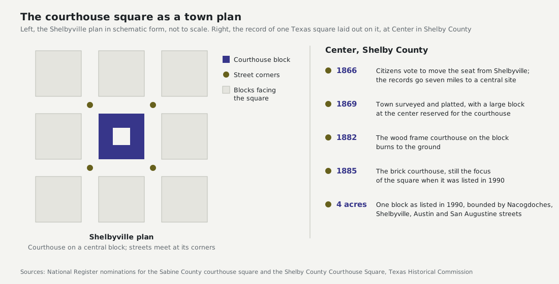
The sheet I have folded in my jacket pocket is a single page printed from a National Register nomination, and the part I have underlined is four lines long. It describes the Shelby County courthouse square at Center as the entire courthouse block, bounded by Nacogdoches, Shelbyville, Austin and San Augustine streets, and it gives the acreage as four.1
I carry it because it answers a question I could not answer for years: when a Texas town was laid out, who decided what went in the middle, and how can I tell from the record what they decided? A boundary description is about as dry as a document gets. It is also a plan, stated in words, for everything that would be built around it.
The general pattern is well documented. The Handbook of Texas says county courthouses sit in prominent positions on public squares, often on land given by the men who founded the town for the purpose of government.2 The Handbook’s broader essay on architecture calls the public square a typical spatial form that Anglo American settlers carried west, and it describes the commercial fronts built to face it and the county jail that usually stood nearby.3 That tells me what the square was. It does not tell me how a particular square was drawn.
The name for one way of drawing it turned up in an unlikely place, a National Register nomination for a single commercial building. The Toole Building faces the courthouse square at Hemphill, in Sabine County, and its nomination describes that square as laid out on a Shelbyville plan, with streets intersecting at the corners and the historic courthouse and jail on the central square.4 Once I knew the term, I found it elsewhere. The nomination for the Jack County courthouse at Jacksboro calls its street grid a modified Shelbyville plan, and the one for Van Zandt County at Canton calls its grid a Shelbyville related pattern.56 The Garza County nomination at Post names a different type altogether, the Harrisonburg plan.7
The diagram above draws the Shelbyville arrangement in the simplest form those sources support: a courthouse on a whole block, with the streets running past it and meeting at its four corners. That geometry does something a reader can see standing on any such square. No street runs straight into the courthouse. Every block around it faces the building across a street, and none of them gets the building’s back.
The courthouse design of the period answered the same geometry from the inside. The Handbook describes antebellum courthouses whose first floors were cut into quarters by corridors that met at the center, with doors on all four sides, and it says the purpose was to give equal prominence to every side of the square.2 The later essay on architecture says the Victorian courthouses kept four similar fronts.3 A building with no back door, set on a block with no back side, made every merchant around the square an equal neighbor of the county. The history of the building type is gathered in the entry on Texas county courthouses.
Here is where I part company with some planners I respect. I think the central courthouse block, in this form, was the most durable piece of town planning Texas ever did, more lasting than any ordinance written since. It set the prices of lots, the placement of banks and the direction of Saturday traffic, and it did so without a single rule anyone had to enforce. Someone could fairly answer that the square also froze towns around a building they soon outgrew, and that the parking lots now ringing many squares are the bill for that. I would still take the trade.
Center shows how deliberately it was done. Shelbyville, the older town, had been settled in the 1820s by people from Tennessee and was the county seat; the Handbook says the county records were moved to the center of the county by night in 1866, which led to a new county seat that year.8 The nomination tells the rest. The new town was named for its central location, surveyed and platted in 1869, and a large block at its center was reserved for the courthouse. The frame courthouse built there burned in 1882, and the brick courthouse of 1885 was still the focus of the square when the nomination was written in 1990.1 One of the four streets bounding the block is named for the town that lost the seat.1
The method has limits, and I have run into them. Terms like the Shelbyville plan are classifications applied by later writers, and the nominations use them loosely, as the modified and related variants show. I went looking for a clear description of a rival form usually paired with it, in which the streets enter the square at the middle of each side, and I could not find one in a source I was willing to cite. So I have left it out of the drawing and out of this essay. A plan type I cannot document is only a guess with a name attached to it.
The fights over where a seat should go belong to another essay, and the county body that ran the building once it stood is described in the essay on county government after 1876. The Dallas version of a courthouse block, and how long county government stayed on it, belongs to a Dallas piece about Old Red. The Texas Historical Commission, which keeps these nominations and is profiled in its reference entry, has made the whole class of record easy to read. These squares are also where the bronze letter mentioned on the civic page now hangs in a growing number of lobbies, a document that first reached Texans as type, as the essay on the Travis letter and its printers argues. The rest of the series is collected under courthouses.
Four acres, four streets, one building. But the number that decided the plan at Center was the distance the records traveled from Shelbyville to the middle of the county. It was seven miles.1
References
-
National Register of Historic Places nomination, Shelby County Courthouse Square, Center, Texas, via Texas Historical Commission Atlas, Shelby County Courthouse Square ↩ ↩2 ↩3 ↩4
-
Handbook of Texas Online, Texas State Historical Association, County Courthouses ↩ ↩2
-
Handbook of Texas Online, Texas State Historical Association, Architecture ↩ ↩2
-
National Register of Historic Places nomination, Toole Building, Hemphill, Sabine County, Texas, via Texas Historical Commission Atlas, Toole Building ↩
-
National Register of Historic Places nomination, Jack County Courthouse, Jacksboro, Texas, Texas Historical Commission, Jack County Courthouse ↩
-
National Register of Historic Places nomination, Van Zandt County Courthouse, Canton, Texas, via Texas Historical Commission Atlas, Van Zandt County Courthouse ↩
-
National Register of Historic Places nomination, Garza County Courthouse, Post, Texas, via Texas Historical Commission Atlas, Garza County Courthouse ↩
-
Handbook of Texas Online, Texas State Historical Association, Shelbyville, TX ↩